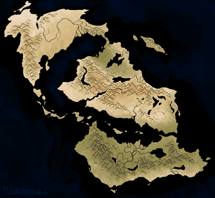
Image Description: A geographical map showing a gaggle of continents: the Sekhenakhen and the Bugetiy'aguto. The Sekhenakhen is above the Bugetiy'aguto, and split into two main sections that are separated by the White Sea and connected by a very thin landbridge; the upper section is largely steppe, with the immense Lipekay-Budva river snaking across it, and a mountain chain running around the far left; the lower section is largely arid and desert -- with the exception of swamp by the landbridge and subtropics in Sekhenakhet Muqegaia next to the Bugetiy'aguto, and split down the middle by the Nabhekhita mountains. As it moves down the continent, the Nabhekhita branches out into two arms, with a desert cupped in the middle. A large crater pockmarks the lower deserts.
Seperating the two continents is only the thin Muqegaian strait, and too running down from the upper Sekhenakhen's mountains and downwards to between the two continents is a long archipelago. The Bugetiy'aguto is largely humid, low wetlands and thick jungles, with the exception of the lower coast. It is split horizontally by the Makke'uno, and split vertically by the Jemirukke river and its massive delta, almost as large as the Lipekay-Budva's. End ID.
Menoyukh'al Map
for Menoyukh'al, Brumaire CCXXXI, digital.
A new map! The last one I had made was from just over 2 years ago and was quite out of date. I had been meaning to I feel much better now.
My maps are usually more stylized than this so this was a fun experiment.